NDE Offshore

NDE Offshore offers complete turn-key solutions to the offshore Oil & Gas and Renewable energy industry.

We will help you get an overview of the aspects of the seabed before you deploy a subsea installation. 

NDE Offshore can provide comprehensive marine, environmental, hydrographical, and geophysical surveys. The surveys will use data from different tools and methods.

Whether you are planning to install a subsea infrastructure or planning a general inspection for maintenance or decommissioning your infrastructure, we can help.

Services

Subsea projects can be complex, depending on the shape, the size, and the weight of the installed material.

We always start by defining the end goal of your project. Once we know your development plans, the location, and the water depth, we can create the plan for the seabed survey. Subsea projects can be complex, depending on the shape, size, and weight of the installed material. We can determine the coverage and type of survey required.

There are two main categories of survey methods used to characterize the seabed. The first is geophysics, which uses an acoustic source and reflections. The other fundamental option is geotechnical investigation, which involves drilling to penetrate a sampling device into the seabed. This is an intrusive process. In such projects, we extract high-quality samples from the subseabed and then undertake a range of further examinations.

NDE Offshore can perform the following surveys:

Multibeam Echo Sounder Survey (MBES)

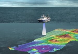
A multibeam echosounder (MBES) is a type of sonar that is used to map the seabed. It emits acoustic waves in a fan shape beneath its transceiver. The time it takes for the sound waves to reflect off the seabed and return to the receiver is used to calculate the water depth.

Side-scan uses a sonar device that emits conical or fan-shaped pulses down toward the seafloor across a wide angle perpendicular to the path of the sensor through the water, which may be towed from a surface vessel.


The Seabed Survey Data Model (SSDM) is an industry-standard for how seabed survey data is stored and managed by oil and gas companies. The International Association of Oil & Gas Producers (IOGP) developed and published this standard in October 2011.[1] Many surveys have been successfully delivered in SSDM.

It is concerned with foundation design, construction, maintenance, and decommissioning for human-made structures in the sea. Oil platforms, artificial islands, and submarine pipelines are examples of such structures. The seabed has to be able to withstand the weight of these structures and the applied loads. Geohazards must also be taken into account.

Geotechnical surveys are performed by geotechnical engineers or engineering geologists to obtain information on the physical properties of soil earthworks and foundations for proposed structures and repair of distress to earthworks and structures caused by subsurface conditions; this type of investigation is called a site investigation.

Pipeline route surveys are performed to determine the feasibility of a proposed pipeline route and to identify any potential environmental or social impacts that may affect its construction and operation.

A pre-lay survey: This essential task is typically carried out as a preliminary step before the installation of subsea cables or pipelines. A post-lay survey: After pipe or cable laying, it is essential to perform a post-lay survey to verify the condition of a pipeline or cable through video footage.

Lorem ipsum dolor sit amet, consectetur adipiscing elit. Ut elit tellus, luctus nec ullamcorper mattis, pulvinar dapibus leo.

Photogrammetry surveys gather measurements and data about an object by analyzing the change in position from two different images, using things like perspective, advanced processing software, and photo analysis to get the job done. It can happen on the ground or in the air.

List of survey related references:

Learn more:

Contact us for more info: sales@ndeofshore.com